Loading data into PostgreSQL
Regina Obe
http://www.paragoncorporation.com
Buy our books! at http://postgis.us/page_buy_book
Our latest book

Categories of loading we'll cover
Server-Side- SQL COPY / COPY FROM PROGRAM
- Large Object storage SQL functions
- Foreign Data Wrappers (FDWs)
- http Extension
Client-Side
- PSQL \copy and \copy FROM PROGRAM
- PSQL Large Object support functions
- Other commandline tools: pgloader, ogr2ogr, shp2pgsql
- Need not be on same server as Postgres service
Loading delimited files with SQL COPY (Server Side)
- postgres daemon account needs to have access to files
- User has to have super user rights to Postgres service
Step 1: Create staging table
Has to match the structure of the file. Using film locations - https://data.sfgov.org/api/views/yitu-d5am/rows.csv?accessType=DOWNLOAD
CREATE TABLE film_locations
   (title text ,
    release_year integer ,
    locations text ,
    fun_facts text ,
    production_company text ,
    distributor text ,
    director text ,
    writer text ,
    actor_1 text ,
    actor_2 text ,
    actor_3 text );
Step 2 (from file): Load the data using SQL COPY
COPY film_locations
FROM '/data_talk/csvs/Film_Locations_in_San_Francisco.csv' HEADER CSV DELIMITER ',';Step 2 (output from program): Load the data using SQL COPY FROM PROGRAM
Requires PostgreSQL 9.3+
COPY film_locations
FROM PROGRAM 'wget -q -O - "$@" "https://data.sfgov.org/api/views/yitu-d5am/rows.csv?accessType=DOWNLOAD"'
    HEADER CSV DELIMITER ',';
Loading delimited files with psql \copy (Client side)
- psql client needs to have access to the files
- User initiating does not need super user rights to database, but needs to have permissions to the files
- Could be slow if postgres server is not on same local network as client.
Step 1: Create staging table
Has to exactly match the structure of the file. Using film locations - https://data.sfgov.org/api/views/yitu-d5am/rows.csv?accessType=DOWNLOAD
CREATE TABLE film_locations
   (title text ,
    release_year integer ,
    locations text ,
    fun_facts text ,
    production_company text ,
    distributor text ,
    director text ,
    writer text ,
    actor_1 text ,
    actor_2 text ,
    actor_3 text );
Step 2: Load the data with \copy FROM
\copy film_locations FROM '/data_talk/csvs/Film_Locations_in_San_Francisco.csv' HEADER CSV DELIMiTER ',';Step 2 alternative: Load the data using \copy FROM PROGRAM
Requires psql compiled for PostgreSQL 9.3+
\copy film_locations FROM PROGRAM 'wget -q -O - "$@" "https://data.sfgov.org/api/views/yitu-d5am/rows.csv?accessType=DOWNLOAD"' HEADER CSV DELIMITER ',';Server Side: Loading Binary files
Loading documents and images into a database table from server's file system.
Use COPY FROM PROGRAM (PostgreSQL 9.3+) in conjunction with Large Object support (LO)
Step 1: Create staging table
CREATE TABLE tmp_docs(file_name text PRIMARY KEY);
Step 2: Get List of files
Pull list from folder with COPY FROM PROGRAM
WindowsCOPY tmp_docs FROM PROGRAM 'dir C:\data /b /S' WITH (format 'csv');COPY tmp_docs FROM PROGRAM 'ls /data/* -R' WITH (format 'csv');Step 2: Add fields to hold file link id and blob of the files
ALTER TABLE tmp_docs ADD COLUMN doc bytea, ADD COLUMN doc_oid oid;Step 3: Load the binary data
-- add the document to large object storage and return the link id
UPDATE tmp_docs SET doc_oid = lo_import(filename);

-- pull document from large object storage
UPDATE tmp_docs SET doc = lo_get(doc_oid);

-- delete the files from large object storage
SELECT lo_unlink(doc_oid)
FROM tmp_docs;
Client Side: Loading Binary files using psql
Loading documents and images into a database table from client's file system.
Use PSQL \copy and \lo_* functions and SQL to generate a load script
Step 1: Create staging table
Note this is same as what we did for the server side approach
CREATE TABLE tmp_docs(file_name text PRIMARY KEY);
Step 2: Get List of files
Pull list from folder with PSQL \copy FROM PROGRAM (psql packaged with 9.3+)
Windows\copy tmp_docs FROM PROGRAM 'dir C:\data /b /S' WITH (format 'csv');\copy tmp_docs FROM PROGRAM 'ls /data/*' WITH (format 'csv');Step 2: Add fields to hold file link id and blob of the files
ALTER TABLE tmp_docs ADD COLUMN doc bytea, ADD COLUMN doc_oid oid;Step 3: Generate a load script file
\t on returns only tuples (no header), and \x off turns off expanded mode, and \a toggles axis align
\o /temp/loadscript.psql
\t on
\x off
\a
SELECT '\lo_import ' || quote_literal(replace(file_name, '\', '/'))
|| '
UPDATE tmp_docs SET doc_oid = :LASTOID
    WHERE  file_name = ' || quote_literal(file_name) || ';'
FROM tmp_docs;
\oStep 4: run the load script file generated in step 3
the load script file will look something like this
\lo_import '/scans/file1.pdf'
UPDATE tmp_docs SET doc_oid = :LASTOID
    WHERE  file_name = E'/scans/file1.pdf';
\lo_import '/scans/file2.pdf'
UPDATE tmp_docs SET doc_oid = :LASTOID
    WHERE  file_name = E'/scans/file2.pdf';
run the load script file generated in step 3
\i /temp/loadscript.psqlStep 5: Same as server side, using server side functions grab the blob and delete the file from large storage
-- pull document from large object storageUPDATE tmp_docs SET doc = lo_get(doc_oid);
-- delete the files from large object storage
SELECT lo_unlink(doc_oid)
FROM tmp_docs;Using Foreign Data Wrappers to load data
- file_fdw: use to read flat files and flat outputs. New in PostgreSQL 10 can read from commandline programs
- postgres_fdw: use to query other postgres servers
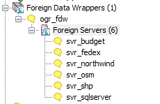
- ogr_fdw - use to query and load spatial formats and also other relational and flat (e.g. spreadsheets, odbc data sources, dbase files, openstreetmap data
- file_text_array - read flat file delimited: each row of data into an array - great where number of columns on each row is not the same like data consisting of orders on one row followed by line items.
- Honorable mentions: multicorn, odbc_fdw, mysql_fdw, oracle_fdw, db2_fdw, tds_fdw
file_fdw
- https://www.postgresql.org/docs/current/static/file-fdw.html
- Generally available with most PostgreSQL packages, may require installing postgresql-contrib if no by default included
- Requires super user to create a foreign table, but user mappings control access.
- New in PostgreSQL 10: can read from output of programs similar to COPY FROM PROGRAM.
Step 1: Install Extension and Create file_fdw Foreign Server
CREATE EXTENSION file_fdw;
CREATE SERVER svr_file FOREIGN DATA WRAPPER file_fdw;
Step 2 (file version): Create Foreign Table to a file system file
CREATE FOREIGN TABLE fdt_film_locations
   (title text ,
    release_year integer ,
    locations text ,
    fun_facts text ,
    production_company text ,
    distributor text ,
    director text ,
    writer text ,
    actor_1 text ,
    actor_2 text ,
    actor_3 text )
    SERVER svr_file
    OPTIONS ( format 'csv', header 'true',
        filename '/data_talk/csvs/Film_Locations_in_San_Francisco.csv',
        delimiter ',',
        null '');
Step 2 (program version): Create Foreign Table from program output
Requires PostgreSQL 10+. This will pull the website data on every query of table.
CREATE FOREIGN TABLE fdt_film_locations
   (title text ,
    release_year integer ,
    locations text ,
    fun_facts text ,
    production_company text ,
    distributor text ,
    director text ,
    writer text ,
    actor_1 text ,
    actor_2 text ,
    actor_3 text )
    SERVER svr_file
    OPTIONS ( format 'csv', header 'true',
     program 'wget -q -O - "$@" "https://data.sfgov.org/api/views/yitu-d5am/rows.csv?accessType=DOWNLOAD"',
     delimiter ',',
     null '');
postgres_fdw: Read from other postgres servers
- Part of standard extension offering so should already have the binaries
- Can read from higher/lower postgres versions, but some features are disabled if both not of same higher version.
- Requires super user to create a foreign table, but user mappings control access.
- New in PostgreSQL 10: Aggregates can be pushed down, which means things like COUNT(*), MAX(*) etc are much faster across databases. More joins can be pushed to remote server thus making cross joins between two databases faster.
Step 1:Install the extension in your database
CREATE EXTENSION postgres_fdw;Step 2:Create Foreign Server
CREATE SERVER remote_db
 FOREIGN DATA WRAPPER postgres_fdw
 OPTIONS (host 'faraway.host.com', dbname 'db', port '5432');
Step 3:Create User Mappings (can be a group or user)
CREATE USER MAPPING FOR public SERVER remote_db OPTIONS (user 'pubinfo', password 'secret');Step 4:Link in the tables
CREATE SCHEMA remote_public;
-- requires PostgreSQL 9.5
IMPORT FOREIGN SCHEMA public FROM SERVER remote_db INTO remote_public;
PostgreSQL + GDAL (OGR) ~ PostGIS = OGR_FDW
PostgreSQL More than Spatial Foreign Data Wrapper
Doesn't require PostGIS to use, but will expose spatial columns as PostGIS geometry if PostGIS is installed.

Use ogr_fdw extension
If you have all sorts of data of both a spatial and non-spatial flavor to tame, make sure you have ogr_fdw foreign data wrapper in your tool belt.
- For windows users using EDB distribution, it's part of PostGIS bundle (versions 2.2 and up) on application stackbuilder.
- For windows/linux/mac desktop users, it's part of the BigSQL PostGIS package.
- For CentOS/Red Hat/Scientific etc, it's available via yum.postgresql.org
- Available via debian and apt.postgresql.org
- For others, if you have PostGIS with GDAL support, just need postgresql dev package to compile. Download the source https://github.com/pramsey/pgsql-ogr-fdw
What can ogr_fdw read?
You have the combined power of Geospatial Data Abstraction Layer (GDAL), PostgreSQL, and any PostgreSQL extension you want (including PostGIS) working seamlessly together. So many kinds of data you can query and take advantage of PostgreSQL functions and any extension functions and types such as PostGIS, hstore, built-in json/jsonb to tame your data.
- Spreadsheets
- ODBC datasources
- Other relational
- OpenStreetMap files (OSM, PBF)
- SQLite, GeoPackage
- Dbase and ESRI Shape files
- Spatial web services
- Many more
Install Binaries
Make sure to use version for your PostgreSQL, examples below are for 11
- Yum (CentOS, RedHat going via yum.postgresql.org) -
yum install ogr_fdw11 - Debian/Ubuntu (via apt.postgresql.org) -
apt install postgresql-11-ogr-fdw - Windows via application Stackbuilder - included as part of PostGIS bundle 2.2 and above bundles
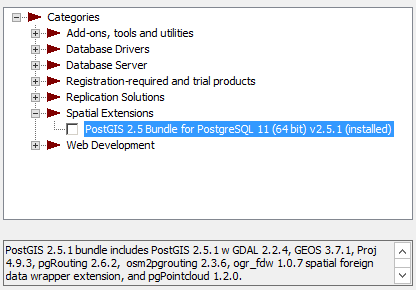 .
. - BigSQL (linux/windows/Mac) - included as part of the PostGIS install:
pgc install postgis25-pg11
Enable it in your database
CREATE EXTENSION ogr_fdw;Load in folder of CSV files
CREATE SCHEMA IF NOT EXISTS staging;
CREATE SERVER svr_csv FOREIGN DATA WRAPPER ogr_fdw
OPTIONS (datasource '/fdw_data/csvs', format 'CSV');
-- requires PostgreSQL 9.5+
IMPORT FOREIGN SCHEMA ogr_all FROM SERVER svr_csv INTO staging;
Other relational databases
Format for SQL Server ODBC 'ODBC:your_user/your_password@yourDSN,table1,table2'. ODBC can be slow with a lot of tables (more than 150) so filter list if you have over 200 tables
CREATE SERVER svr_sqlserver FOREIGN DATA WRAPPER ogr_fdw
OPTIONS (datasource 'ODBC:pguser/whatever@MSSQLTest,dbo.IssueLog,dbo.IssueNotes',
format 'ODBC'
);
CREATE SCHEMA IF NOT EXISTS ss;
IMPORT FOREIGN SCHEMA "dbo."
FROM SERVER svr_sqlserver INTO ss;
\dE ss.*List of relations Schema | Name | Type | Owner --------+----------------+---------------+---------- ss | dbo_issuelog | foreign table | postgres ss | dbo_issuenotes | foreign table | postgres (2 rows)
Spreadsheets
Each workbook is considered a server and each sheet a table
CREATE SERVER svr_currency_rates
   FOREIGN DATA WRAPPER ogr_fdw
  OPTIONS (datasource '/fdw_data/ExchangeRates.xlsx',format 'XLSX',
    config_options 'OGR_XLSX_HEADERS=FORCE');
CREATE SCHEMA staging;
-- link only 2 spreadsheets preserve headers (requires PostgreSQL 9.5 to use IMPORT FOREIGN SCHEMA)
IMPORT FOREIGN SCHEMA ogr_all LIMIT TO (EUR, USD)
	FROM SERVER svr_currency_rates INTO staging
OPTIONS (launder_column_names 'false');file_text_array: Loading delimited files and jagged files with file_text_array
- Usually not available from distros but fairly easy compile
- We have a windows 32/64-bit builds https://tinyurl.com/y8bojebk
- Source code here: https://github.com/adunstan/file_text_array_fdw (note different branch for each version of PostgreSQL)
- New in PostgreSQL 10: can read from output of programs similar to COPY FROM PROGRAM.
step 1: Create Extension and Server
CREATE EXTENSION file_textarray_fdw;
CREATE SERVER file_ta_server FOREIGN DATA WRAPPER file_textarray_fdw;
CREATE USER MAPPING FOR public SERVER file_ta_server;
step 2 (file version): Create FOREIGN TABLE
CREATE FOREIGN TABLE fdt_film_locations_ta( x text[] ) SERVER file_ta_server
OPTIONS (filename '/data_talk/csvs/Film_Locations_in_San_Francisco.csv', encoding 'latin1', delimiter E',');
step 2 (program version): Create FOREIGN TABLE
Requires PostgreSQL 10+
CREATE FOREIGN TABLE fdt_film_locations_ta( x text[] ) SERVER file_ta_server
OPTIONS (program 'wget -q -O - "$@" "https://data.sfgov.org/api/views/yitu-d5am/rows.csv?accessType=DOWNLOAD"', encoding 'latin1', delimiter E',');
Query the web from PostgreSQL with http
A web browser in your database
- We've compiled binaries for windows users (pg 9.4-11) http://www.postgresonline.com/journal/archives/371-http.html
- Compile instructions for debian/ubuntu -http://www.postgresonline.com/journal/archives/393-http.html
- Download the source https://github.com/pramsey/pgsql-http
Install in database
CREATE EXTENSION http;Query NYC Open Data
Last 5 logged NYC 311 calls
WITH h AS (SELECT r
            FROM
                http_get('https://data.cityofnewyork.us/resource/fhrw-4uyv.json?'
                    || '$order=' || urlencode('created_date DESC')
                    || '&$limit=5') AS hg
                        , jsonb_array_elements(hg.content::jsonb) As r)
SELECT r->>'complaint_type' AS complaint
    , r->>'borough' As borough
    , (r->>'longitude')::numeric(8,4) As long
    , (r->>'latitude')::numeric(8,4) As lat
    , (r->>'created_date')::timestamp AS date_create
FROM h;
complaint | borough | long | lat | date_create -------------------------------------+-----------+----------+---------+--------------------- Request Large Bulky Item Collection | QUEENS | -73.8082 | 40.7418 | 2019-03-16 02:59:00 Request Large Bulky Item Collection | BROOKLYN | -73.9599 | 40.6498 | 2019-03-16 02:55:00 Noise - Commercial | QUEENS | -73.7027 | 40.7519 | 2019-03-16 02:14:42 Noise - Commercial | MANHATTAN | -73.9558 | 40.7763 | 2019-03-16 02:13:36 Blocked Driveway | BRONX | -73.8634 | 40.8690 | 2019-03-16 02:12:20 (5 rows)
Commandline Tools
Commonly available Open source command-line when you have PostgreSQL / PostGIS installed.
- pgloader
- shp2pgsql- use to load Dbase and ESRI shapefiles, generally part of based postgis or postgis-gui package
- ogr2ogr - Binaries and packages available for most server and Desktop OS ( https://trac.osgeo.org/gdal/wiki/DownloadingGdalBinaries ). Use to load any kind of data, specially designed for spatial vector data.
pgloader: What is it
An open source command-line tool for loading data into PostgreSQL: Key features: (source: https://github.com/dimitri/pgloader)
- Supported relational: MySQL, SQL Server, SQLite, PostgreSQL
- Supported file formats: CSV, Dbase
- Can pull from http/https and also compressed (zip)
- Scriptable Load, has a basic scripting language for more granular control
- Supports parallel loading
pgloader: Installing it
Binaries available via apt.postgresql.org and yum.postgresql.org. FreeBSD pkg system Mac Users there is homebrew script. No binaries available for Windows.
Install Debian/Ubuntuapt install pgloaderyum install pgloaderpkg install pgloaderpgloader --version
pgloader --help Output
pgloader version "3.4.1"
    compiled with SBCL 1.3.3.debian
      --help -h                       boolean  Show usage and exit.
      --version -V                    boolean  Displays pgloader version and exit.
      --quiet -q                      boolean  Be quiet
      --verbose -v                    boolean  Be verbose
      --debug -d                      boolean  Display debug level information.
      --client-min-messages           string   Filter logs seen at the console (default: "warning")
      --log-min-messages              string   Filter logs seen in the logfile (default: "notice")
      --summary -S                    string   Filename where to copy the summary
      --root-dir -D                   string   Output root directory. (default: #P"/tmp/pgloader/")
      --upgrade-config -U             boolean  Output the command(s) corresponding to .conf file for
                                               v2.x
      --list-encodings -E             boolean  List pgloader known encodings and exit.
      --logfile -L                    string   Filename where to send the logs.
      --load-lisp-file -l             string   Read user code from files
      --dry-run                       boolean  Only check database connections, don't load anything.
      --on-error-stop                 boolean  Refrain from handling errors properly.
      --with                          string   Load options
      --set                           string   PostgreSQL options
      --field                         string   Source file fields specification
      --cast                          string   Specific cast rules
      --type                          string   Force input source type
      --encoding                      string   Source expected encoding
      --before                        string   SQL script to run before loading the data
      --after                         string   SQL script to run after loading the data
      --self-upgrade                  string   Path to pgloader newer sources
      --regress                       boolean  Drive regression testing
Example table for load
create table cd116
(
         usps        text,
         geoid       text,
         aland       bigint,
         awater      bigint,
         aland_sqmi  double precision,
         awater_sqmi double precision,
         intptlat    double precision,
         intptlong   double precision
);
File we'll be loading is from http://www2.census.gov/geo/docs/maps-data/data/gazetteer/2018_Gazetteer/2018_Gaz_116CDs_national.zip
pgloader load CSV file from stdin
Database pgconf and table cd116 must exist
pgloader --type csv \
             --with "skip header = 1"  \
             --with "fields terminated by '\t'" \
             -    \
             postgresql://postgres@localhost:5432/pgconf?cd116 \
             < 2018_Gaz_116CDs_national.txt
2019-03-18T00:10:15.062000Z LOG pgloader version "3.6.1"
2019-03-18T00:10:15.569000Z LOG report summary reset
table name errors rows bytes total time
----------------------- --------- --------- --------- --------------
fetch 0 0 0.009s
----------------------- --------- --------- --------- --------------
"public"."cd116" 0 440 28.2 kB 0.230s
----------------------- --------- --------- --------- --------------
Files Processed 0 1 0.030s
COPY Threads Completion 0 2 0.231s
----------------------- --------- --------- --------- --------------
Total import time âo" 440 28.2 kB 0.261s
pgloader SQLite (on web) to postgres
Both source and target databases need to exist
pgloader https://github.com/lerocha/chinook-database/raw/master/ChinookDatabase/DataSources/Chinook_Sqlite_AutoIncrementPKs.sqlite postgresql://postgres@localhost:5432/pgconf
table name     errors       rows      bytes      total time
-----------------------  ---------  ---------  ---------  --------------
                  fetch          0          0                     1.490s
        fetch meta data          0         44                     0.078s
         Create Schemas          0          0                     0.001s
       Create SQL Types          0          0                     0.012s
          Create tables          0         22                     0.112s
         Set Table OIDs          0         11                     0.023s
-----------------------  ---------  ---------  ---------  --------------
                  album          0        347    10.5 kB          0.122s
                 artist          0        275     6.8 kB          0.274s
               customer          0         59     6.7 kB          0.066s
                  genre          0         25     0.3 kB          0.116s
            invoiceline          0       2240    43.6 kB          0.303s
               employee          0          8     1.4 kB          0.274s
                invoice          0        412    31.0 kB          0.362s
              mediatype          0          5     0.1 kB          0.321s
          playlisttrack          0       8715    57.3 kB          0.439s
               playlist          0         18     0.3 kB          0.152s
                  track          0       3503   236.6 kB          0.389s
-----------------------  ---------  ---------  ---------  --------------
COPY Threads Completion          0          4                     0.473s
         Create Indexes          0         33                     0.544s
 Index Build Completion          0         33                     0.181s
        Reset Sequences          0         10                     0.052s
           Primary Keys          0         11                     0.017s
    Create Foreign Keys          0         11                     0.045s
        Create Triggers          0          0                     0.000s
       Install Comments          0          0                     0.000s
-----------------------  ---------  ---------  ---------  --------------
      Total import time          âo"      15607   394.5 kB          1.312s
ogr2ogr: Swiss army knife for data loading
ogr2ogr --formatsSupported Formats: PCIDSK -raster,vector- (rw+v): PCIDSK Database File JP2OpenJPEG -raster,vector- (rwv): JPEG-2000 driver based on OpenJPEG library PDF -raster,vector- (w+): Geospatial PDF MBTiles -raster,vector- (rw+v): MBTiles ESRI Shapefile -vector- (rw+v): ESRI Shapefile MapInfo File -vector- (rw+v): MapInfo File UK .NTF -vector- (rov): UK .NTF OGR_SDTS -vector- (rov): SDTS S57 -vector- (rw+v): IHO S-57 (ENC) DGN -vector- (rw+v): Microstation DGN OGR_VRT -vector- (rov): VRT - Virtual Datasource REC -vector- (ro): EPIInfo .REC Memory -vector- (rw+): Memory BNA -vector- (rw+v): Atlas BNA CSV -vector- (rw+v): Comma Separated Value (.csv) GML -vector- (rw+v): Geography Markup Language (GML) GPX -vector- (rw+v): GPX KML -vector- (rw+v): Keyhole Markup Language (KML) GeoJSON -vector- (rw+v): GeoJSON ESRIJSON -vector- (rov): ESRIJSON TopoJSON -vector- (rov): TopoJSON OGR_GMT -vector- (rw+v): GMT ASCII Vectors (.gmt) GPKG -raster,vector- (rw+vs): GeoPackage SQLite -vector- (rw+v): SQLite / Spatialite ODBC -vector- (rw+): ODBC WAsP -vector- (rw+v): WAsP .map format PGeo -vector- (ro): ESRI Personal GeoDatabase MSSQLSpatial -vector- (rw+): Microsoft SQL Server Spatial Database OpenFileGDB -vector- (rov): ESRI FileGDB XPlane -vector- (rov): X-Plane/Flightgear aeronautical data DXF -vector- (rw+v): AutoCAD DXF CAD -raster,vector- (rovs): AutoCAD Driver Geoconcept -vector- (rw+v): Geoconcept GeoRSS -vector- (rw+v): GeoRSS GPSTrackMaker -vector- (rw+v): GPSTrackMaker VFK -vector- (ro): Czech Cadastral Exchange Data Format PGDUMP -vector- (w+v): PostgreSQL SQL dump OSM -vector- (rov): OpenStreetMap XML and PBF GPSBabel -vector- (rw+): GPSBabel SUA -vector- (rov): Tim Newport-Peace's Special Use Airspace Format OpenAir -vector- (rov): OpenAir OGR_PDS -vector- (rov): Planetary Data Systems TABLE HTF -vector- (rov): Hydrographic Transfer Vector AeronavFAA -vector- (rov): Aeronav FAA Geomedia -vector- (ro): Geomedia .mdb EDIGEO -vector- (rov): French EDIGEO exchange format SVG -vector- (rov): Scalable Vector Graphics Idrisi -vector- (rov): Idrisi Vector (.vct) ARCGEN -vector- (rov): Arc/Info Generate SEGUKOOA -vector- (rov): SEG-P1 / UKOOA P1/90 SEGY -vector- (rov): SEG-Y XLS -vector- (ro): MS Excel format ODS -vector- (rw+v): Open Document/ LibreOffice / OpenOffice Spreadsheet XLSX -vector- (rw+v): MS Office Open XML spreadsheet Walk -vector- (ro): Walk SXF -vector- (rov): Storage and eXchange Format Selafin -vector- (rw+v): Selafin JML -vector- (rw+v): OpenJUMP JML VDV -vector- (rw+v): VDV-451/VDV-452/INTREST Data Format MVT -vector- (rov): Mapbox Vector Tiles TIGER -vector- (rw+v): U.S. Census TIGER/Line AVCBin -vector- (rov): Arc/Info Binary Coverage AVCE00 -vector- (rov): Arc/Info E00 (ASCII) Coverage
ogr2ogr load data into PostgreSQL
Can use psql variables or be specified on commandline
Load an OpenStreetMap protobuf file
ogr2ogr -f "PostgreSQL" \
	"PG:host=localhost user=postgres password=xxx dbname=pgconf" sf.osm.pbf
Load a folder of CSV files (folder is called csvs)
ogr2ogr -f "PostgreSQL" \
	"PG:host=localhost user=postgres password=xxx dbname=pgconf" /csvs